Elevation can impact a hunt in countless ways. Sometimes elevation can be helpful and at other times devastating. High elevation often has sparse forage, cold temperatures, low humidity and can provide ideal escape routes for animals. Low elevation is typically more calorie rich with vegetation, warmer and filled with bipeds. Because of this duality, hunters tend to use elevation for its advantages and avoid its disadvantages. Variations in elevation are as important to the hunter as are absolute elevations. Gaining 2000’ in elevation starting at 3500’ or starting at 9000’ over ½ mile is tough regardless of one’s initial starting point. In short elevation matters a lot.
One too many times, we’ve found ourselves a little under prepared for elevation changes on a hunting trip. Yeah we looked at topo maps. Yes, we looked at trail elevation plots. Maybe we even looked at some esoteric ruggedness score. All of these observations never really sunk in for some reason. So thinking that we were not the only ones having this problem, we set out to answer a simple yet complex question: “What’s the elevation like in a unit?”
Now we don’t think we’ve solved this problem for good but at least we put a dent in it. We do think we’ve approached elevation from a hunter first perspective. This perspective yields some pretty good insight into what a hunter might experience when hunting a unit.
On Ruggedness
The traditional measure for comparing the elevation of two geographies is through a ruggedness index initially proposed by Riley, S. J., S. D. DeGloria and R. Elliot (1999) in their paper “A terrain ruggedness index that quantifies topographic heterogeneity” in the Intermountain Journal of Sciences, vol. 5, No. 1-4,1999. The calculation is relatively straightforward. Imagine a grid where at every intersection of latitude and longitude an elevation was known. Pick an intersection and then calculate the sum of squared elevation gain/loss from that point and its eight neighbors. Then take the square root to get back to the original scale. Voila! You have a measure that roughly captures how elevation changes around a point.
While this is a useful measure, we here at HuntScore thought it lacked reality. Hunters typically set out from a road or trailhead. There are often large swaths of land that aren’t accessed, like mountain peaks. Also, the more road access that exists, the more likely hunters will frequent the area. Also, most folks tend to stay close to trails and roads. Many won’t venture more than 2 miles from a road or trail, so why not bias a ruggedness measure toward reality?
A New Approach
To compute HuntScore’s Ease of Terrain index, we threw on our data science GIS hats and created an entirely new view of terrain. First, we leveraged road and trail networks in the US. For each unit we cover, we find all the roads and trails contained within the unit. Then we randomly sample points along the roads and trails. These points serve as starting points for our synthetic hunters. We randomly send these hunters on hikes, anywhere from half a mile to 2 miles from their jumping off point. While heading out on the hike, we track the elevation change of the hunter moving from start to finish. To do this, we leverage a state of the art dataset from NASA.
The Shuttle Radar Topography Mission released topography data that covers most of the globe over the last several years. Previous datasets had granularity at best of 15 or 30 arc seconds. Recent datasets are more granular to 3 or 1 arc seconds. 3 arc seconds is roughly 90 meter intervals while 1 arc second is approximately 30 meters or 98 feet. For our synthetic hunter, we use the most granular data available and track the hunters elevation gain and loss at 1 arc second.
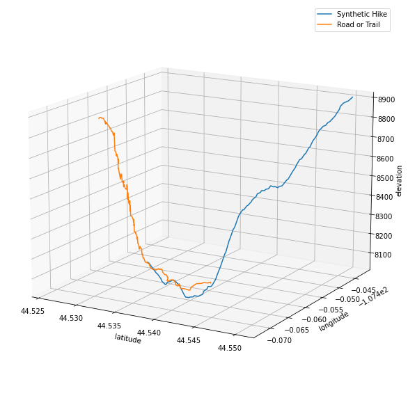
An example hike with elevation gain and loss is shown above. Most units will end up with anywhere between 2,000-10,000 synthetic hikes. From these hikes we produce a smattering of statistics for hunters to consume. These statistics aid in hunt selection, hunt fitness, survival planning and nutrition selection. We break down elevation into 4 primary dimensions:
-
Slope distribution - distribution of elevation changes experienced by synthetic hunters. Provides an overview of how the terrain in a unit varies. If the distribution is skewed to the right, it’s steep country so start running stairs. If it skews to the left, congratulations you found flat land. If it’s generally mixed then you’ll only hate yourself some of the time.
-
Common slope - if you had to train your body to withstand one particular incline/decline, this would be it. If you can hike 2 miles at this incline, you should be moderately prepared for what the unit can throw at you.
-
Elevation range - since this is based on hikes done by our synthetic hunters, it won’t simply be the highest and lowest points in the unit. Of particular interest is the median elevation. If this is far from the highest or lowest elevations it can tell you if the unit is generally more like the peak or valley.
-
Elevation profiles - remember all those hikes our synthetic hunters did? Well, we use some machine learning clustering techniques to group together similar hikes. Then we pick the 10 largest groupings and extract elevation profiles that our synthetic hunters experienced on those hikes. Use these as another point of comparison between units, as way to understand the variability of elevation within a unit or as another way to pick or prepare for a hunt.