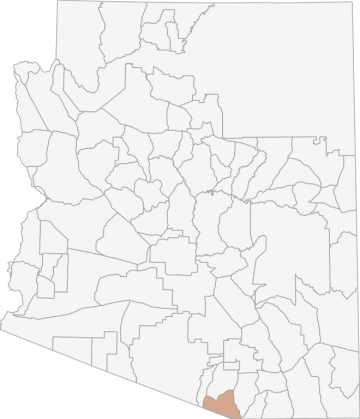
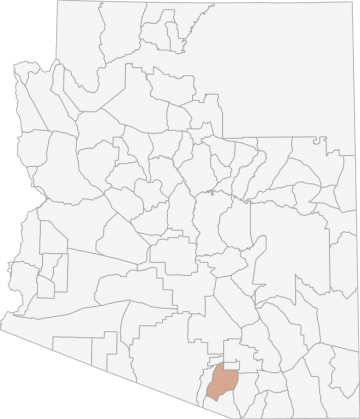
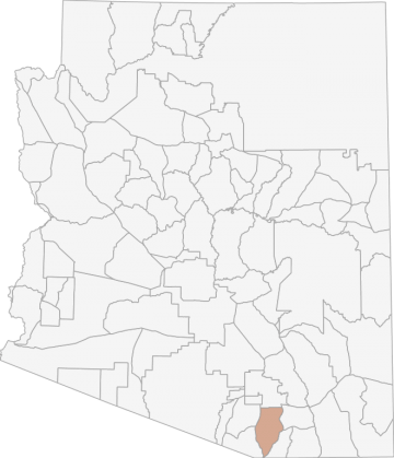
All Hunting in Arizona Game Management Unit 36B
Steep mountainous terrain with oak woodland habitat type surrounded by rolling hills with a mesquite grassland cover. The elevation in this area ranges from 3,000 feet in the valleys to 6,200 feet at Atascosa Peak.
Scores
Access Notes
With A Free Account Get:
- All Access Information
- Satallite and Topo Layers
- Public Landownership Layers
- Roads and Trails Layers
- Burn Layers
- Water Tank Layer (AZ Only)
Beginning at I-19 and Grand Avenue (U.S. Hwy 89) in Nogales; southwest on Grand Avenue to the U.S.-Mexico border; west along the U.S.-Mexico border to AZ Hwy 286; north on AZ Hwy 286 to the Arivaca-Sasabe Rd.; southeasterly on the Arivaca-Sasabe Rd. to the town of Arivaca; from the town of Arivaca northeasterly on the Arivaca Rd. to I-19; south on I-19 to Grand Avenue (U.S. Hwy 89).
A portion of the western half of the unit is on the Buenos Aires National Wildlife Refuge. Guns must be unloaded and cased when traveling on Refuge roads. You must also camp in designated camping s... Create a free account to read the rest of this access note!
All Notes
With A Free Account Get:
- Toggle between terrain, satellite, and topographic views
- Additional species-specific map layers
- Full screen maps
- Complete species hunting information
HuntScore Tip
Quality binoculars mounted on a tripod used systematically to glass whitetail habitat is the most effective method used to locate the elusive Coues deer.
State Agency Website
Visit Arizona Game and Fish DepartmentBusinesses Serving All Hunters In Game Management Unit 36B
Advertise Your Business!

Category: Guide/Outfitter
: 555-555-5555
About
Are you an outfitter, hunting guide, game processor or local hotel? Do you have landowner tags, lease land, or have an lodge? Advertise on HuntScore and reach hunters interested in this hunting unit! Send us an email at [email protected] to learn more. Read about advertising on huntscore here
Photos and Terrain Notes
Steep mountainous terrain with oak woodland habitat type surrounded by rolling hills with a mesquite grassland cover. The elevation in this area ranges from 3,000 feet in the valleys to 6,200 feet... Create a free account to read the rest of this terrain note!
All Drawing Stats (2023)
1st Choice Draw Odds
| Stats | Apply For | Sex | Manner | Season | Type | Draw Odds | HuntScore | Notes |
|---|---|---|---|---|---|---|---|---|
| 36B_J_1_E_HAM_S_LL |
E
|
HAM
|
S
|
LL
|
84.6%
|
0 | 2023 Hunt Code: 5078 | |
| 36B_J_1_E_ALL_S_LL |
E
|
ALL
|
S
|
LL
|
80.9%
|
0 | 2023 Hunt Code: 5029 | |
| 36B(CHAMP)_J_1_E_ALL_S_C |
E
|
ALL
|
S
|
C
|
84.2%
|
0 | 2023 Hunt Code: 5048 | |
| 36B_J_1_E_ALL_S_Y |
E
|
ALL
|
S
|
Y
|
100%
|
0 | 2023 Hunt Code: 5047 | |
| 36B_J_1_E_A_S_LL |
E
|
A
|
S
|
LL
|
92.1%
|
0 | 2023 Hunt Code: 5097 |
Go Pro and get:
- Most up to date data!
- Drawing trends across multiple years
- Individual hunt quotas
- 1st choice license applications and licenses drawn
- Draw odds for resident and nonresident applicants
- Minimum preference points to draw
- Point creep plots
See all stats but the last 2 years with a free account!
All Harvest Stats (2021)
| Manner | Season | Type | Sex | Hunters | Harvest | Male | Female | Youth |
|---|---|---|---|---|---|---|---|---|
|
A
|
S
|
LL
|
E
|
422 | 0 |
0
|
0
|
0
|
|
ALL
|
S
|
LL
|
E
|
460 | 0 |
0
|
0
|
0
|
|
ALL
|
S
|
Y
|
E
|
65 | 0 |
0
|
0
|
0
|
|
HAM
|
S
|
LL
|
E
|
151 | 0 |
0
|
0
|
0
|
Go Pro and get:
- Most up to date data!
- Harvest trends across multiple years
- Harvest stats by hunt_code, manner, season, sex, type
- Average harvest rates
- Average days per hunter
- Overall harvest trends
See all stats but the last 2 years with a free account!
Weather Insights
Weather can vary by elevation. See how weather varies by elevation within a unit by selecting an elevation range. Elevation ranges are based on weather stations in or near the unit. Not all weather elements are available within the unit.
Average Temps
Use temperature ranges to plan and prepare for your hunt. Large swings indicate a good layering system should be used. Be sure to make note of the extreme temperatures as these often pose the greatest risk to hunters. If you plan on hunting in higher elevation, as a rule of thumb, expect the tempture to decrease roughly 5° for every 1000' in elevation gain.
WITH A FREE ACCOUNT GET:
- Precip totals by month
- Snow depth by month
- Min/Max precip and snow depth
- Average # of days between precip or snow event
- Wind speed and wind direction by month
- Sunshine and cloud cover stats by month
- Probability of other weather events (thunder, hail, etc...) by by month
Similar Nearby All Units

TrailHead Chatter
With A Free Account Get:
- Ability to read comments
- Ability to post comments
- Ability to upvote and downvote comments