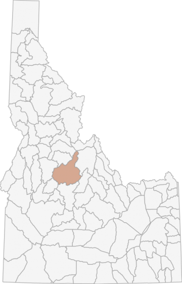
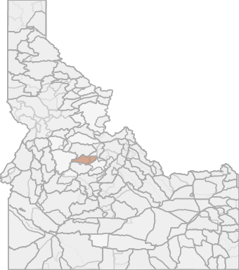
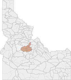
All Hunting in Idaho Unit 27 - Middle Fork Elk Zone - Southwest Region - Region 7
The terrain in this unit is 99% forest and 1% rangeland.
Scores
Access Notes
With A Free Account Get:
- All Access Information
- Satallite and Topo Layers
- Public Landownership Layers
- Roads and Trails Layers
- Burn Layers
- Water Tank Layer (AZ Only)
Those portions of Lemhi, Valley, and Custer counties within the drainage of the Middle Fork of the Salmon River as follows: the drainages on the east side of the Middle Fork Salmon River from its mouth upstream to Camas Creek; the drainages on the north side of Camas Creek from its mouth upstream to, but excluding, the Yellowjacket Creek drainage; the drainages on the south side of Camas Creek from its mouth upstream to Fell Creek and south of the Camas Creek Trail (Forest Service Trail 134) from J Fell Creek to the Custer County line; the drainages on the east side of the Middle Fork Salmon River from Camas Creek upstream to, but excluding, the Marsh Creek drainage; and the drainages on the west side of the Middle Fork of the Salmon River upstream from, but excluding, the Big Creek drainage to, but excluding, the Sulphur Creek drainage.
27-1 Sheep
That portion of Unit 27 west of the Middle Fork of the Salmon River upstream from, but excluding, the Brush Creek drainage to and including the Indian Creek drainage.27-2 Goat
That portion of Unit 27 south of Forest Service Road 172 from Loon Creek Summit to Loon Creek guard station, piñon Peak, and Feltham Creek Point, and that portion of Unit 36 west of Forest Service Road 172 and north of the Pioneer CreekWest Fork Yankee Fork Trail, Forest Service Trail 113-155.27-2 Sheep
That portion of Unit 27 east of the Middle Fork of the Salmon River upstream from its mouth to the Waterfall Creek Trail (Forest Service Trail 045).27-3 Sheep
That portion of Unit 27 east of the Middle Fork of the Salmon River upstream from the Waterfall Creek Trail (Forest Service Trail 045) to and including the Camas Creek drainage on the north side of Camas Creek, and that portion of Unit 28 within the Camas Creek drainage north of Camas Creek and west of the Silver Creek-Meyers Cove Road (Forest Service Road 108).27-4 Sheep
That portion of Unit 27 within the Loon Creek drainage; that portion of Unit 27 east of the Middle Fork of the Salmon River, south of Camas Creek, and northwest of Fly Creek Trail (Forest Service Trail 124); that portion of Unit 36 within the Yankee Fork drainage.27-4 Goat
That portion of Unit 27 east of the Middle Fork of the Salmon River and north of Camas Creek and that portion of Unit 28 within the Yellowjacket Creek drainage.27-5 Sheep
That portion of Unit 27 within the Loon Creek drainage; that portion of Unit 27 east of the Middle Fork of the Salmon River, south of Camas Creek, and northwest of Fly Creek Trail (Forest Service Trail 124).27-5 Goat
That portion of Unit 27 west of the Middle Fork of the Salmon River upstream from and including the Marble Creek drainage, and that part east of the Middle Fork of the Salmon River upstream from and including Little Loon Creek drainage.27L Sheep
That portion of Unit 20A within the Middle Fork of the Salmon River drainage, and that portion of Unit 27 on the west side of the Middle Fork of the Salmon River downstream from but excluding the Pistol Creek drainage and the east side of the Middle Fork of the Salmon River downstream from but excluding the Camas Creek drainage.All Notes
With A Free Account Get:
- Toggle between terrain, satellite, and topographic views
- Additional species-specific map layers
- Full screen maps
- Complete species hunting information
HuntScore Tip
The quality of your hunt depends on you. Preseason scouting, preparation for the environmental conditions, and physical conditioning are important factors. The success and quality of your hunt will likely increase with the distance from your vehicle and roads.
State Agency Website
Visit Idaho Fish and GameOther Species in Unit
Deer, Elk, Shiras Moose, Black Bear, Mountain Lion, Gray Wolf, Rocky Mountain Bighorn Sheep, Rocky Mountain Goat,Businesses Serving All Hunters In Unit 27 - Middle Fork Elk Zone - Southwest Region - Region 7
Advertise Your Business!

Category: Guide/Outfitter
: 555-555-5555
About
Are you an outfitter, hunting guide, game processor or local hotel? Do you have landowner tags, lease land, or have an lodge? Advertise on HuntScore and reach hunters interested in this hunting unit! Send us an email at [email protected] to learn more. Read about advertising on huntscore here
Photos and Terrain Notes
The terrain in this unit is 99% forest and 1% rangeland.
... Create a free account to read the rest of this terrain note!Similar Nearby All Units

TrailHead Chatter
With A Free Account Get:
- Ability to read comments
- Ability to post comments
- Ability to upvote and downvote comments