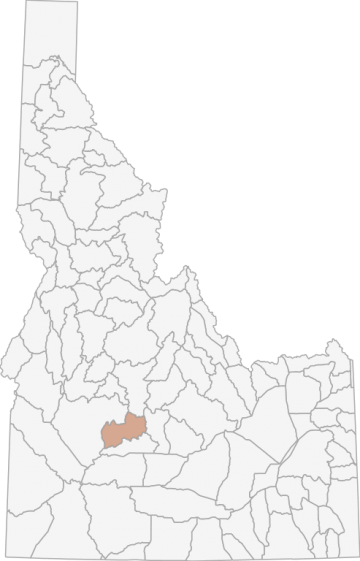
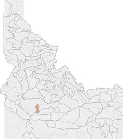
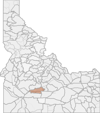
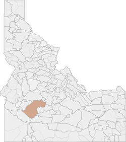
Elk Hunting in Idaho Unit 43 - Smoky Mountains Elk Zone - Magic Valley Region - Region 4
The terrain in this unit is approximately 75% forest and 25% rangeland.
Scores
Access Notes
With A Free Account Get:
- All Access Information
- Satallite and Topo Layers
- Public Landownership Layers
- Roads and Trails Layers
- Burn Layers
- Water Tank Layer (AZ Only)
Those portions of Camas and Elmore counties within the following boundary: beginning at the confluence of the South Fork of the Boise River and Fall Creek (center of Anderson Ranch Reservoir), then up Fall Creek to the Anderson Ranch ReservoirFall Creek-Trinity Mountain-Rocky Bar-James Creek Road, then north on Anderson Ranch Reservoir-Fall Creek-Trinity MountainRocky Bar-James Creek Road to James Creek Summit, then east along the watershed divide between the Middle and South Forks of the Boise River to the intersection with the Elmore-Camas County line, then north along the Elmore-Camas County line to the junction with the Camas-Blaine County line, then southeast along the Camas-Blaine County line to the Dollarhide Summit-Carrie Creek-Little Smoky Creek Road (Forest Service Road 227), then southwest on Dollarhide Summit-Carrie Creek-Little Smoky Creek Road to the Five Points Creek-Couch Summit Road (Forest Service Road 094), then south on Five Points Creek-Couch Summit Road to Couch Summit, then west along the South Fork of the Boise River- Camas Creek watershed divide to Iron Mountain, then southwest on the Forest Service trail to and down the Middle Fork of Lime Creek to Lime Creek (Forest Service Trails 050 and 049), then downstream to the South Fork of the Boise River (middle of Anderson Ranch Reservoir) to the confluence of Fall Creek, the point of beginning. Goat: That portion of Unit 36 west of State Highway 75 and south of Alturas Lake Creek; all of Unit 43; and that portion of Unit 48 south and west of State Highway 75 upstream from and including the Baker Creek drainage.
Elk Notes
With A Free Account Get:
- Toggle between terrain, satellite, and topographic views
- Additional species-specific map layers
- Full screen maps
- Complete species hunting information
HuntScore Tip
The quality of your hunt depends on you. Preseason scouting, preparation for the environmental conditions, and physical conditioning are important factors. The success and quality of your hunt will likely increase with the distance from your vehicle and roads.
Management Plan
State Agency Website
Visit Idaho Fish and GameBusinesses Serving Elk Hunters In Unit 43 - Smoky Mountains Elk Zone - Magic Valley Region - Region 4
Advertise Your Business!

Category: Guide/Outfitter
: 555-555-5555
About
Are you an outfitter, hunting guide, game processor or local hotel? Do you have landowner tags, lease land, or have an lodge? Advertise on HuntScore and reach hunters interested in this hunting unit! Send us an email at [email protected] to learn more. Read about advertising on huntscore here
Photos and Terrain Notes
The terrain in this unit is approximately 75% forest and 25% rangeland.
... Create a free account to read the rest of this terrain note!Similar Nearby Elk Units
TrailHead Chatter
With A Free Account Get:
- Ability to read comments
- Ability to post comments
- Ability to upvote and downvote comments