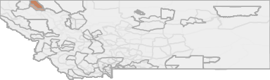
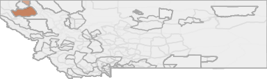
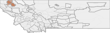
All Hunting in Montana HD 110 - North Fork
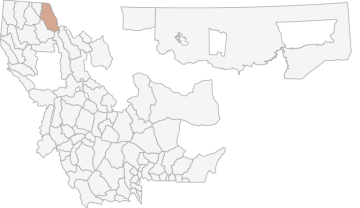
The Whitefish EMU is located in northwestern Montana and encompasses 1,067 square miles of land from Columbia Falls to the Canadian border. However, in 2002 a new hunting district (HD 109) was created from that portion of HD 101 located on the east sid...
Scores
Access Notes
With A Free Account Get:
- All Access Information
- Satallite and Topo Layers
- Public Landownership Layers
- Roads and Trails Layers
- Burn Layers
- Water Tank Layer (AZ Only)
Those portions of Flathead and Lincoln Counties lying within the following described boundary: Beginning at the mouth of the North Fork of the Flathead River, then northerly up the river to the Canadian border, then westerly along said border to the divide between Weasel Creek and the North Fork of the Flathead River, then southerly along said divide to the Russky Creek Road, then westerly along said road to Stillwater Road 900, then southerly along said road to US Highway 93 at Stryker then southerly along said highway to junction of East 2nd Street, then easterly and northerly to East Edgewood Drive, then easterly along said drive to Tamarack Lane, then easterly along said lane to 12th Ave NW, then southerly along said avenue to US Highway 2, then easterly along said highway to the Flathead River, then northerly along said river to the mouth of the North Fork of the Flathead River, the point of beginning.
Although most of this EMU has undergone some level of timber harvesting, concerns over grizzly bear security has resulted in the closure of many roads during the past 2 decades. Many hunters consid... Create a free account to read the rest of this access note!
All Notes
With A Free Account Get:
- Toggle between terrain, satellite, and topographic views
- Additional species-specific map layers
- Full screen maps
- Complete species hunting information
The Whitefish EMU is located in northwestern Montana and encompasses 1,067 square miles of land from Columbia Falls to the Canadian border. Most of the area is drained by the North Fork of the Flat... Create a free account to read the rest of this hunting note!
HuntScore Tip
Public land and private land percentages can sometime be misleading. A unit may have 80% public land, but a particluar species may only occupy 20% on the entire area. And that 20% species distribution may lie 100% within private lands. Does that sound confusing? Just remember that there are always exceptions to the rule, and land ownership is just one piece of the puzzle.
State Agency Website
Visit Montana Fish, Wildlife & ParksBusinesses Serving All Hunters In HD 110 - North Fork
Advertise Your Business!

Category: Guide/Outfitter
: 555-555-5555
About
Are you an outfitter, hunting guide, game processor or local hotel? Do you have landowner tags, lease land, or have an lodge? Advertise on HuntScore and reach hunters interested in this hunting unit! Send us an email at [email protected] to learn more. Read about advertising on huntscore here
Photos and Terrain Notes
All Over The Counter Hunts (2022)
There are 6 OTC hunts in this unit. Get a free account to view the details!
With a free account get:
- Most up to date data!
- The ability to filter OTC units by residency and manner/sex
- Over the counter unit hunts listed with:
- Residency Requirements
- Season and Manner of Take Restrictions
- Season Dates
All Drawing Stats (2022)
1st Choice Draw Odds
| Stats | Apply For | Sex | Manner | Season | Type | Draw Odds | HuntScore | Notes |
|---|---|---|---|---|---|---|---|---|
| 110-00-B |
F
|
ANY
|
P0
|
|
29.8%
|
58 | Only valid on private land. | |
| 110-50-A |
|
ANY
|
G
|
|
1.7%
|
63 | ||
| 110-00-B |
F
|
ANY
|
P0
|
|
29.8%
|
58 | Only valid on private land. | |
| 110-50-A |
|
ANY
|
G
|
|
1.7%
|
63 |
Go Pro and get:
- Most up to date data!
- Drawing trends across multiple years
- Individual hunt quotas
- 1st choice license applications and licenses drawn
- Draw odds for resident and nonresident applicants
- Minimum preference points to draw
- Point creep plots
See all stats but the last 2 years with a free account!
All Harvest Stats (2021)
| Manner | Season | Type | Sex | Hunters | Harvest | Male | Female | Youth |
|---|---|---|---|---|---|---|---|---|
|
ALL
|
ALL
|
NA
|
N/A | 0 | 27 |
19
|
8
|
0
|
|
ALL
|
ALL
|
NA
|
N/A | 9 | 8 |
8
|
0
|
0
|
|
ALL
|
ALL
|
NA
|
N/A | 1118 | 323 |
307
|
16
|
0
|
|
Any
|
Any
|
N
|
N/A | 0 | 3 |
3
|
0
|
0
|
|
Any
|
Any
|
N
|
N/A | 1 | 0 |
0
|
0
|
0
|
|
Any
|
Any
|
N
|
N/A | 22 | 7 |
7
|
0
|
0
|
|
Any
|
Any
|
R
|
N/A | 0 | 24 |
16
|
8
|
0
|
|
Any
|
Any
|
R
|
N/A | 8 | 8 |
8
|
0
|
0
|
|
Any
|
Any
|
R
|
N/A | 1096 | 316 |
300
|
16
|
0
|
Go Pro and get:
- Most up to date data!
- Harvest trends across multiple years
- Harvest stats by hunt_code, manner, season, sex, type
- Average harvest rates
- Average days per hunter
- Overall harvest trends
See all stats but the last 2 years with a free account!
Weather Insights
Weather can vary by elevation. See how weather varies by elevation within a unit by selecting an elevation range. Elevation ranges are based on weather stations in or near the unit. Not all weather elements are available within the unit.
Average Temps
Use temperature ranges to plan and prepare for your hunt. Large swings indicate a good layering system should be used. Be sure to make note of the extreme temperatures as these often pose the greatest risk to hunters. If you plan on hunting in higher elevation, as a rule of thumb, expect the tempture to decrease roughly 5° for every 1000' in elevation gain.
WITH A FREE ACCOUNT GET:
- Precip totals by month
- Snow depth by month
- Min/Max precip and snow depth
- Average # of days between precip or snow event
- Wind speed and wind direction by month
- Sunshine and cloud cover stats by month
- Probability of other weather events (thunder, hail, etc...) by by month
Similar Nearby All Units
TrailHead Chatter
With A Free Account Get:
- Ability to read comments
- Ability to post comments
- Ability to upvote and downvote comments