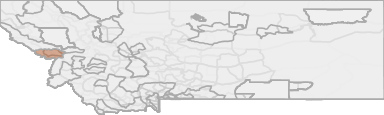
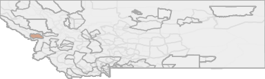
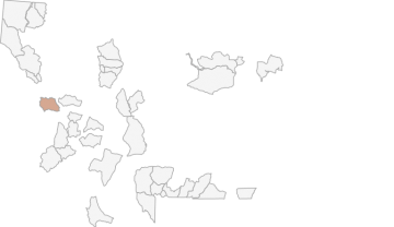
All Hunting in Montana HD 230 - Lolo-Fish Creek
Those portions of Mineral, Missoula and Ravalli Counties lying within the followingdescribed boundary: Beginning at the junction of U.S. Highway 93 and Carlton Lake Road, then westerly along said road to Carlton Lake, then westerly to Lolo Peak, then sout
Scores
Access Notes
With A Free Account Get:
- All Access Information
- Satallite and Topo Layers
- Public Landownership Layers
- Roads and Trails Layers
- Burn Layers
- Water Tank Layer (AZ Only)
Those portions of Mineral, Missoula and Ravalli Counties lying within the followingdescribed boundary: Beginning at the junction of U.S. Highway 93 and Carlton Lake Road, then westerly along said road to Carlton Lake, then westerly to Lolo Peak, then southwesterly following the divide between the South Fork of Lolo Creek and the Bitterroot River to the Montana-Idaho border, then along said border westerly and northerly to USFS Trail 620W, then north along said trail to Quartz Creek-North Fork Fish Creek Divide, then east along said divide to USFS Trail 176T, then north along said trail to Quartz Creek, then northeast along said creek to the Clark Fork River, then east along said river to Interstate 90, then southeast along said interstate to the Reserve Street Exit at Missoula, then south along Reserve Street to U.S. Highway 93, then southwest along said highway to Carlton Lake Road the point of beginning.
All Notes
With A Free Account Get:
- Toggle between terrain, satellite, and topographic views
- Additional species-specific map layers
- Full screen maps
- Complete species hunting information
HuntScore Tip
Public land and private land percentages can sometime be misleading. A unit may have 80% public land, but a particluar species may only occupy 20% on the entire area. And that 20% species distribution may lie 100% within private lands. Does that sound confusing? Just remember that there are always exceptions to the rule, and land ownership is just one piece of the puzzle.
State Agency Website
Visit Montana Fish, Wildlife & ParksBusinesses Serving All Hunters In HD 230 - Lolo-Fish Creek
Advertise Your Business!

Category: Guide/Outfitter
: 555-555-5555
About
Are you an outfitter, hunting guide, game processor or local hotel? Do you have landowner tags, lease land, or have an lodge? Advertise on HuntScore and reach hunters interested in this hunting unit! Send us an email at [email protected] to learn more. Read about advertising on huntscore here
Photos and Terrain Notes
All Harvest Stats (2021)
| Manner | Season | Type | Sex | Hunters | Harvest | Male | Female | Youth |
|---|---|---|---|---|---|---|---|---|
|
ALL
|
ALL
|
NA
|
N/A | 4 | 4 |
4
|
0
|
0
|
|
Any
|
Any
|
R
|
N/A | 4 | 4 |
4
|
0
|
0
|
Go Pro and get:
- Most up to date data!
- Harvest trends across multiple years
- Harvest stats by hunt_code, manner, season, sex, type
- Average harvest rates
- Average days per hunter
- Overall harvest trends
See all stats but the last 2 years with a free account!
Weather Insights
Weather can vary by elevation. See how weather varies by elevation within a unit by selecting an elevation range. Elevation ranges are based on weather stations in or near the unit. Not all weather elements are available within the unit.
Average Temps
Use temperature ranges to plan and prepare for your hunt. Large swings indicate a good layering system should be used. Be sure to make note of the extreme temperatures as these often pose the greatest risk to hunters. If you plan on hunting in higher elevation, as a rule of thumb, expect the tempture to decrease roughly 5° for every 1000' in elevation gain.
WITH A FREE ACCOUNT GET:
- Precip totals by month
- Snow depth by month
- Min/Max precip and snow depth
- Average # of days between precip or snow event
- Wind speed and wind direction by month
- Sunshine and cloud cover stats by month
- Probability of other weather events (thunder, hail, etc...) by by month
Similar Nearby All Units
TrailHead Chatter
With A Free Account Get:
- Ability to read comments
- Ability to post comments
- Ability to upvote and downvote comments