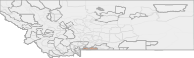
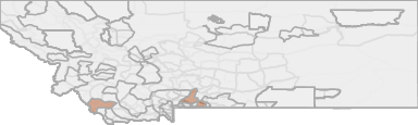
All Hunting in Montana HD 385 - Gardiner Basin and Absaroka/Beartooth
Gardiner Basin Portion AND Absaroka Beartooth Portion (wilderness north of Yellowstone National Park including the upper portions of the Hellroaring and Slough Creek drainages).
Scores
Access Notes
With A Free Account Get:
- All Access Information
- Satallite and Topo Layers
- Public Landownership Layers
- Roads and Trails Layers
- Burn Layers
- Water Tank Layer (AZ Only)
Gardiner Basin Portion – Beginning at the boundary intersection of
Yellowstone National Park and the Absaroka-Beartooth Wilderness just
east of Gardiner, then northerly and westerly along said Wilderness
boundary to USFS Trail #64 near the Bear Creek campground, then
northerly along said trail to the intersection with USFS Trail #62, then
northwesterly along USFS Trail #62 to the watershed divide east of
Monitor Peak, then northwesterly along the watershed divide over Monitor
Peak to Red Mountain, then southwesterly along the watershed divide to
Dome Mountain, then southwesterly in a direct line to the bison-resistant
cattle guard across U.S. HWY 89 in Yankee Jim Canyon, then southerly
in a direct line to crest of watershed divide between Sphinx Creek and
Tom Miner Creek Basin, then southerly along the watershed divide over
Black Mountain to the boundary of Yellowstone National Park at Shooting
Star Mountain, then generally east along the Yellowstone National Park
boundary to the boundary intersection of Yellowstone National Park
and the Absaroka-Beartooth Wilderness just east of Gardiner, the point
of beginning.
NOTE: Gardiner Hunting Closure: Closed to all hunting: Beginning at
the Junction of U.S. Hwy 89 and Little Trail Creek, then up Little Trail
Creek to the posted line (approx. 1/2 mile above U.S. Hwy 89), then
southeasterly along said line to the Travertine-Trail Creek Road, then
easterly along said road to its intersection with the Gardiner-Jardine
Road, then northeasterly along said road to Eagle Creek, then southerly
down said creek to the YNP boundary, then westerly along said boundary
to the intersection with Stevens Creek, then northeasterly in a straight
line to the intersection with U.S. Hwy 89, then northwesterly along said
highway to the junction of Little Trail Creek, the point of beginning.
AND
Absaroka Beartooth Portion (wilderness north of Yellowstone
National Park including the upper portions of the Hellroaring and Slough
Creek drainages) – The entire Hellroaring, Buffalo Fork, and Slough
creeks drainages north of Yellowstone National Park.
Gardiner Basin Portion AND Absaroka Beartooth Portion (wilderness north of Yellowstone National Park including the upper portions of the Hellroaring and Slough Creek drainages).
... Create a free account to read the rest of this access note!All Notes
With A Free Account Get:
- Toggle between terrain, satellite, and topographic views
- Additional species-specific map layers
- Full screen maps
- Complete species hunting information
HuntScore Tip
Public land and private land percentages can sometime be misleading. A unit may have 80% public land, but a particluar species may only occupy 20% on the entire area. And that 20% species distribution may lie 100% within private lands. Does that sound confusing? Just remember that there are always exceptions to the rule, and land ownership is just one piece of the puzzle.
State Agency Website
Visit Montana Fish, Wildlife & ParksBusinesses Serving All Hunters In HD 385 - Gardiner Basin and Absaroka/Beartooth
Advertise Your Business!

Category: Guide/Outfitter
: 555-555-5555
About
Are you an outfitter, hunting guide, game processor or local hotel? Do you have landowner tags, lease land, or have an lodge? Advertise on HuntScore and reach hunters interested in this hunting unit! Send us an email at [email protected] to learn more. Read about advertising on huntscore here
Photos and Terrain Notes
The Absoraka-Beartooth portion is a very remote wilderness accessible only by foot or horse. Retrieving a harvested bison will present an extraordinary challenge. A mature bull bison can weigh 2,00... Create a free account to read the rest of this terrain note!
Weather Insights
Weather can vary by elevation. See how weather varies by elevation within a unit by selecting an elevation range. Elevation ranges are based on weather stations in or near the unit. Not all weather elements are available within the unit.
Average Temps
Use temperature ranges to plan and prepare for your hunt. Large swings indicate a good layering system should be used. Be sure to make note of the extreme temperatures as these often pose the greatest risk to hunters. If you plan on hunting in higher elevation, as a rule of thumb, expect the tempture to decrease roughly 5° for every 1000' in elevation gain.
WITH A FREE ACCOUNT GET:
- Precip totals by month
- Snow depth by month
- Min/Max precip and snow depth
- Average # of days between precip or snow event
- Wind speed and wind direction by month
- Sunshine and cloud cover stats by month
- Probability of other weather events (thunder, hail, etc...) by by month
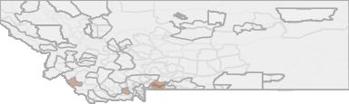
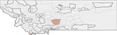
Similar Nearby All Units
TrailHead Chatter
With A Free Account Get:
- Ability to read comments
- Ability to post comments
- Ability to upvote and downvote comments