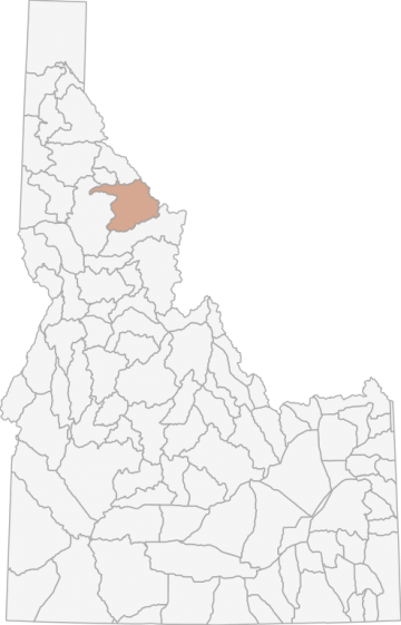
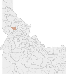
Elk Hunting in Idaho Unit 10 - Lolo Elk Zone - Clearwater Region - Region 2
The land area in this unit is approximately 73% forest and 27% rangeland.
Scores
Access Notes
With A Free Account Get:
- All Access Information
- Satallite and Topo Layers
- Public Landownership Layers
- Roads and Trails Layers
- Burn Layers
- Water Tank Layer (AZ Only)
Those portions of Shoshone, Clearwater, and Idaho counties within the following boundary: beginning at the confluence of the Little North Fork and the North Fork of the Clearwater Rivers at the upstream end of Dworshak Reservoir, then up the east bank of the reservoir and the Little North Fork of the Clearwater River to the watershed divide between Bear and Devils Club Creeks, then east along the divide to the watershed divide between the Little North Fork and the North Fork of the Clearwater Rivers, then east along the divide to the watershed divide between the North Fork of the Clearwater and the St. Joe Rivers, then east along the divide to the Idaho-Montana State line, then south along the state line to the divide between the North Fork of the Clearwater and the Lochsa Rivers, then west along the divide over Williams Peak to its intersection with the Lolo Motor Way (Forest Service Road 500), then west on Lolo Motor Way to its intersection with the Hemlock Butte Road (Forest Service Road 104), then northwest on Hemlock Butte Road to Hemlock Butte and the watershed divide between Weitas and Orogrande Creeks, then north along the divide to Cabin Point then northwest along Forest Service Trail 17 to the North Fork Clearwater River then downstream along the North Fork of the Clearwater River and the north bank of Dworshak Reservoir to the mouth of the Little North Fork of the Clearwater River, the point of beginning. 10-1 Goat: That portion of Unit 10 within the Isabella Creek and Collins Creek drainage. 10-1
Moose
That portion of Unit 10 within the Cayuse Creek drainage. 10-2Moose
That portion of Unit 10 on the north side of the Kelly Creek drainage upstream from, but excluding, the Moose Creek drainage, and that portion on the south side of the Kelly Creek drainage upstream from, but excluding, the Cayuse Creek drainage. 10-2 Goat: Those portions of Units 10 and 12 within the following boundary: Beginning at Lolo Pass, then southwest on U.S. 12 to Forest Service Road 569, then north on Forest Service Road 569 to Forest Service Road 500, then west on Forest Service Road 500 to Cayuse Junction, then north and west along Toboggan Ridge Road (Forest Service Road 581) to Rapid Creek Trail (Forest Service Trail 565), then north along Rapid Creek Trail to Kelly Creek Trail (Forest Service Trail 567), then northeast on Kelly Creek Trail to the Idaho-Montana state line, then south along the Idaho-Montana state line to Lolo Pass, the point of beginning. 10-3Moose
That portion of Unit 10 on the north side of the Kelly Creek drainage upstream from its mouth to and including the Moose Creek drainage, and the North Fork of the Clearwater River drainage upstream from the mouth of Kelly Creek. 10-4Moose
That portion of Unit 10 within the Fourth of July Creek drainage, that portion on the south side of the North Fork of the Clearwater River from the mouth of Fourth of July Creek upstream to the mouth of Kelly Creek, and the south side of the Kelly Creek drainage from its mouth upstream to, but excluding, the Cayuse Creek drainage. 10-5Moose
That portion of Unit 10 within the Weitas Creek drainage (a tributary of the upper North Fork of the Clearwater River), and the drainages on the southwest side of the North Fork of the Clearwater River from the Weitas Creek drainage to, but excluding, the Fourth of July Creek drainage. 10-6Moose
That portion of Unit 10 on the north side of the North Fork of the Clearwater River drainage downstream from the mouth of Kelly Creek.Elk Notes
With A Free Account Get:
- Toggle between terrain, satellite, and topographic views
- Additional species-specific map layers
- Full screen maps
- Complete species hunting information
HuntScore Tip
Public land and private land percentages can sometime be misleading. A unit may have 80% public land, but a particluar species may only occupy 20% on the entire area. And that 20% species distribution may lie 100% within private lands. Does that sound confusing? Just remember that there are always exceptions to the rule, and land ownership is just one piece of the puzzle.
Management Plan
State Agency Website
Visit Idaho Fish and GameOther Species in Unit
Deer, Rocky Mountain Goat, Shiras Moose, Black Bear, Mountain Lion, Turkey, Gray Wolf,Businesses Serving Elk Hunters In Unit 10 - Lolo Elk Zone - Clearwater Region - Region 2
Advertise Your Business!

Category: Guide/Outfitter
: 555-555-5555
About
Are you an outfitter, hunting guide, game processor or local hotel? Do you have landowner tags, lease land, or have an lodge? Advertise on HuntScore and reach hunters interested in this hunting unit! Send us an email at [email protected] to learn more. Read about advertising on huntscore here
Photos and Terrain Notes
The land area in this unit is approximately 73% forest and 27% rangeland.
... Create a free account to read the rest of this terrain note!Similar Nearby Elk Units


TrailHead Chatter
With A Free Account Get:
- Ability to read comments
- Ability to post comments
- Ability to upvote and downvote comments