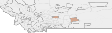
Mountain Lion Hunting in Montana HD 540 - South Little Belt Mountains
This 3,585-square-mile EMU encompasses the area in and around the Little Belt Mountains, which are located south and east of Great Falls, and north and east of White Sulphur Springs. Private land, including coniferous elk habitat, surrounds the Little ...
Scores
Access Notes
Land Ownership
Legend
Those portions of Meagher and Wheatland Counties lying within the following-described boundary: Beginning at Harlowton, then westerly along US Highway 12 to Spring Creek-Whitetail Cabin Road (USFS Road 274), then northerly along said road to its intersection with the Willow Park Road (USFS Road 189), then easterly along said road to its intersection with USFS Trail 603, then easterly along said trail to the Mt. High Lookout Tower, then easterly along USFS Road 382 to a permanent boundary marker (Wheatland/Judith Basin county line) then northeasterly along the Wheatland County line to US Highway 191, then southerly along said highway to Harlowton, the point of beginning.
Access varies across the EMU and among hunting districts. Portions of the EMU currently have high road densities, providing easy access by vehicle, but other areas are reasonably remote and better ... Create a free account to read the rest of this access note!
Mountain Lion Notes
HuntScore Tip
Public land and private land percentages can sometime be misleading. A unit may have 80% public land, but a particluar species may only occupy 20% on the entire area. And that 20% species distribution may lie 100% within private lands. Does that sound confusing? Just remember that there are always exceptions to the rule, and land ownership is just one piece of the puzzle.
State Agency Website
Visit Montana Fish, Wildlife & ParksBusinesses Serving Mountain-lion Hunters In HD 540 - South Little Belt Mountains
Advertise Your Business!

Category: Guide/Outfitter
: 555-555-5555
About
Are you an outfitter, hunting guide, game processor or local hotel? Do you have landowner tags, lease land, or have an lodge? Advertise on HuntScore and reach hunters interested in this hunting unit! Send us an email at [email protected] to learn more. Read about advertising on huntscore here
Photos and Terrain Notes
Unit Elevation Profile
HuntScore generates thousands of synthetic hikes in the unit to create an elevation profile. This profile is what you can expect to experience within a 2 mile hike from a road or trail in this unit.
Elevation in this unit ranges from 4117' to 8133' with a median elevation of 5602'. If you are preparing to hunt this unit you should train for hiking up and down slopes of 6.3%.
This is typical incline or decline experienced while hiking from a road or trail in the unit
Common Elevation Profiles
Weather Insights
Weather can vary by elevation. See how weather varies by elevation within a unit by selecting an elevation range. Elevation ranges are based on weather stations in or near the unit. Not all weather elements are available within the unit.
Average Temps
Use temperature ranges to plan and prepare for your hunt. Large swings indicate a good layering system should be used. Be sure to make note of the extreme temperatures as these often pose the greatest risk to hunters. If you plan on hunting in higher elevation, as a rule of thumb, expect the tempture to decrease roughly 5° for every 1000' in elevation gain.
WITH A FREE ACCOUNT GET:
- Precip totals by month
- Snow depth by month
- Min/Max precip and snow depth
- Average # of days between precip or snow event
- Wind speed and wind direction by month
- Sunshine and cloud cover stats by month
- Probability of other weather events (thunder, hail, etc...) by by month
Precipitation
The probability of precipitation is the likelihood of experience rain, snow, hail, etc... on a given day within the month. A good trick is to invert the probability to estimate how many days will pass, on average, between precipitation events. Hover or click a month to see how many days will pass between precipitation events.
Use the average and maximum precipitation events to set expetations for what rain gear to bring. Also remember that water availability can influence wildlife patterns, so be sure to check out the current weather patterns leading up to your hunt.
Snow
Each month of the year brings it's own challenges for weather. Select a month to see what you can expect and how to prepare for extreme events.
Likely Wind Directions
Wind Speed
Sunshine
Cloud Cover
Other Weather Events
TrailHead Chatter
With A Free Account Get:
- Ability to read comments
- Ability to post comments
- Ability to upvote and downvote comments