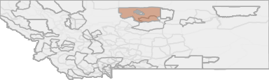
Mountain Lion Hunting in Montana HD 690 - Hill-Blaine-Chouteau
Located in north-central Montana, this EMU encompasses 2,821 square miles. Elk habitat includes about 200-square-miles of the Bears Paw Mountains about 30 to 40 miles south of Havre and 100 square miles of the Missouri River Breaks in the Lion Coulee, ...
Scores
Access Notes
With A Free Account Get:
- All Access Information
- Satallite and Topo Layers
- Public Landownership Layers
- Roads and Trails Layers
- Burn Layers
- Water Tank Layer (AZ Only)
Those portions of Hill, Blaine and Chouteau Counties lying within the following-described boundaries (excluding the Rocky Boys Indian Reservation and portions of the Fort Belknap Indian Reservation lying within the exterior boundaries of HD 690): Beginning at a point where the Hill-Liberty County Line meets US Highway 2, three miles west of Inverness, then south along said county line to the Marias River, then southerly along said river to US Highway 87 near Loma, then northeast on said highway to the junction with Route 236 at Big Sandy, then southeast along said route to the Cow Island Trail, then southeast along said trail to Lloyd Road, then north on said road to Cow Creek, then southeast along said creek to Suction Creek, then northeast along said creek to Little Suction Creek, then east along said creek to the Fort Belknap Indian Reservation boundary, then north along said boundary to the Milk River, then east along said river to US Highway 2 at Fort Belknap Indian Agency, then north and west along said highway to the Hill-Liberty County Line three miles west of Inverness, the point of beginning.
Because elk hunting in this unit is primarily a means to control game damage, access to private lands has traditionally been granted to elk permit holders. An elk hunter management coordinator has ... Create a free account to read the rest of this access note!
Mountain Lion Notes
With A Free Account Get:
- Toggle between terrain, satellite, and topographic views
- Additional species-specific map layers
- Full screen maps
- Complete species hunting information
HuntScore Tip
Public land and private land percentages can sometime be misleading. A unit may have 80% public land, but a particluar species may only occupy 20% on the entire area. And that 20% species distribution may lie 100% within private lands. Does that sound confusing? Just remember that there are always exceptions to the rule, and land ownership is just one piece of the puzzle.
State Agency Website
Visit Montana Fish, Wildlife & ParksBusinesses Serving Mountain-lion Hunters In HD 690 - Hill-Blaine-Chouteau
Advertise Your Business!

Category: Guide/Outfitter
: 555-555-5555
About
Are you an outfitter, hunting guide, game processor or local hotel? Do you have landowner tags, lease land, or have an lodge? Advertise on HuntScore and reach hunters interested in this hunting unit! Send us an email at [email protected] to learn more. Read about advertising on huntscore here
Photos and Terrain Notes
Weather Insights
Weather can vary by elevation. See how weather varies by elevation within a unit by selecting an elevation range. Elevation ranges are based on weather stations in or near the unit. Not all weather elements are available within the unit.
Average Temps
Use temperature ranges to plan and prepare for your hunt. Large swings indicate a good layering system should be used. Be sure to make note of the extreme temperatures as these often pose the greatest risk to hunters. If you plan on hunting in higher elevation, as a rule of thumb, expect the tempture to decrease roughly 5° for every 1000' in elevation gain.
WITH A FREE ACCOUNT GET:
- Precip totals by month
- Snow depth by month
- Min/Max precip and snow depth
- Average # of days between precip or snow event
- Wind speed and wind direction by month
- Sunshine and cloud cover stats by month
- Probability of other weather events (thunder, hail, etc...) by by month
TrailHead Chatter
With A Free Account Get:
- Ability to read comments
- Ability to post comments
- Ability to upvote and downvote comments