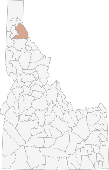
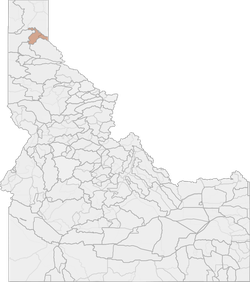
Shiras Moose Hunting in Idaho Unit 4 - Panhandle Elk Zone - Panhandle Region - Region 1
The terrain of this area varies from approximately 3% rangeland, 93% forest, 25 riparian, and 1% dryland agriculture.
Scores
Access Notes
With A Free Account Get:
- All Access Information
- Satallite and Topo Layers
- Public Landownership Layers
- Roads and Trails Layers
- Burn Layers
- Water Tank Layer (AZ Only)
Those portions of Bonner, Kootenai, and Shoshone counties within the following boundary: beginning on the Idaho Montana State line at the watershed divide between Pend Oreille Lake and the Coeur d̥Alene River, then southeast along the state line to the watershed divide between the Coeur d̥Alene and St. Joe Rivers, then west along the divide to State Highway 3, then northeast on State Highway 3 to Interstate 90, then east on Interstate 90 to Kingston, then north on Forest Highway 9 (North Fork of the Coeur d̥Alene River Road) to Forest Service Road 209 (Little North Fork of the Coeur d̥Alene River Road), then northwest along Forest Service Road 209, then north along Forest Road 385 to the watershed divide between the Coeur d̥Alene River and Pend Oreille Lake, then northeast along the divide to the point of beginning.
Shiras Moose Notes
With A Free Account Get:
- Toggle between terrain, satellite, and topographic views
- Additional species-specific map layers
- Full screen maps
- Complete species hunting information
HuntScore Tip
Public land and private land percentages can sometime be misleading. A unit may have 80% public land, but a particluar species may only occupy 20% on the entire area. And that 20% species distribution may lie 100% within private lands. Does that sound confusing? Just remember that there are always exceptions to the rule, and land ownership is just one piece of the puzzle.
State Agency Website
Visit Idaho Fish and GameBusinesses Serving Shiras-moose Hunters In Unit 4 - Panhandle Elk Zone - Panhandle Region - Region 1
Advertise Your Business!

Category: Guide/Outfitter
: 555-555-5555
About
Are you an outfitter, hunting guide, game processor or local hotel? Do you have landowner tags, lease land, or have an lodge? Advertise on HuntScore and reach hunters interested in this hunting unit! Send us an email at [email protected] to learn more. Read about advertising on huntscore here
Photos and Terrain Notes
The terrain of this area varies from approximately 3% rangeland, 93% forest, 25 riparian, and 1% dryland agriculture.
... Create a free account to read the rest of this terrain note!Similar Nearby Shiras-moose Units
TrailHead Chatter
With A Free Account Get:
- Ability to read comments
- Ability to post comments
- Ability to upvote and downvote comments