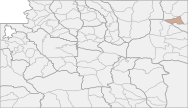
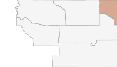
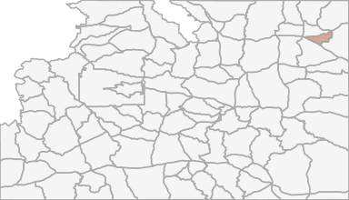
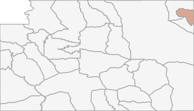
All Hunting in Wyoming Hunt Area 5 - Inyan Kara
Beginning where Interstate Highway 90 crosses Wyoming Highway 585 in the town of Sundance; southeasterly along Wyoming Highway 585 to the Skull Creek Road (Weston County Road 14); westerly along said road to the Green Mountain Road (Weston County Road 11)
Scores
Access Notes
With A Free Account Get:
- All Access Information
- Satallite and Topo Layers
- Public Landownership Layers
- Roads and Trails Layers
- Burn Layers
- Water Tank Layer (AZ Only)
Beginning where Interstate Highway 90 crosses Wyoming Highway 585 in the town of Sundance; southeasterly along Wyoming Highway 585 to the Skull Creek Road (Weston County Road 14); westerly along said road to the Green Mountain Road (Weston County Road 11); northerly along said road to the Dry Creek Road (Weston County Road 13); northwesterly along said road to Wyoming Highway 116; southwesterly along said highway to U.S. Highway 16 in the town of Upton; northwesterly along said highway to Interstate Highway 90 at the town of Moorcroft; easterly along said Interstate Highway to Wyoming Highway 585 at the town of Sundance.
All Notes
With A Free Account Get:
- Toggle between terrain, satellite, and topographic views
- Additional species-specific map layers
- Full screen maps
- Complete species hunting information
HuntScore Tip
All Wyoming antelope hunt areas are managed under a limited quota framework, meaning there are a set number of licenses valid for each specific hunt area. All hunt areas have full-price "any" antelope licenses (Type 0, 1, 2 or 9). Most hunt areas also provide reduced-price limited quota "doe/fawn" licenses (Type 6, 7 or 8), which can be obtained separately or in addition to a full-price license.
State Agency Website
Visit Wyoming Game & Fish DepartmentBusinesses Serving All Hunters In Hunt Area 5 - Inyan Kara
Advertise Your Business!

Category: Guide/Outfitter
: 555-555-5555
About
Are you an outfitter, hunting guide, game processor or local hotel? Do you have landowner tags, lease land, or have an lodge? Advertise on HuntScore and reach hunters interested in this hunting unit! Send us an email at [email protected] to learn more. Read about advertising on huntscore here
Photos and Terrain Notes
All Harvest Stats (2021)
| Manner | Season | Type | Sex | Hunters | Harvest | Male | Female | Youth |
|---|---|---|---|---|---|---|---|---|
|
ALL
|
ALL
|
ALL
|
N/A | 407 | 177 |
110
|
67
|
0
|
|
ALL
|
ALL
|
ALL
|
N/A | 308 | 115 |
77
|
38
|
0
|
|
ALL
|
ALL
|
ALL
|
N/A | 308 | 115 |
77
|
38
|
0
|
|
ALL
|
ALL
|
ALL
|
N/A | 407 | 177 |
110
|
67
|
0
|
|
F
|
RS
|
N/A | 214 | 88 |
59
|
29
|
0
|
|
|
F
|
6
|
|
N/A | 75 | 22 |
0
|
22
|
0
|
|
F
|
G
|
|
N/A | 352 | 120 |
110
|
10
|
0
|
|
F
|
G
|
|
N/A | 352 | 120 |
110
|
10
|
0
|
|
F
|
G
|
|
N/A | 276 | 93 |
77
|
16
|
0
|
|
F
|
6
|
|
N/A | 128 | 57 |
0
|
57
|
0
|
|
F
|
NRS
|
N/A | 94 | 27 |
18
|
9
|
0
|
|
|
F
|
6
|
|
N/A | 128 | 57 |
0
|
57
|
0
|
|
F
|
6
|
|
N/A | 75 | 22 |
0
|
22
|
0
|
|
F
|
NRS
|
N/A | 94 | 27 |
18
|
9
|
0
|
|
|
F
|
NRS
|
N/A | 189 | 99 |
51
|
48
|
0
|
|
|
F
|
NRS
|
N/A | 189 | 99 |
51
|
48
|
0
|
|
|
F
|
RS
|
N/A | 214 | 88 |
59
|
29
|
0
|
|
|
F
|
RS
|
N/A | 218 | 78 |
59
|
19
|
0
|
|
|
F
|
RS
|
N/A | 218 | 78 |
59
|
19
|
0
|
|
|
F
|
G
|
|
N/A | 276 | 93 |
77
|
16
|
0
|
Go Pro and get:
- Most up to date data!
- Harvest trends across multiple years
- Harvest stats by hunt_code, manner, season, sex, type
- Average harvest rates
- Average days per hunter
- Overall harvest trends
See all stats but the last 2 years with a free account!
Weather Insights
Weather can vary by elevation. See how weather varies by elevation within a unit by selecting an elevation range. Elevation ranges are based on weather stations in or near the unit. Not all weather elements are available within the unit.
Average Temps
Use temperature ranges to plan and prepare for your hunt. Large swings indicate a good layering system should be used. Be sure to make note of the extreme temperatures as these often pose the greatest risk to hunters. If you plan on hunting in higher elevation, as a rule of thumb, expect the tempture to decrease roughly 5° for every 1000' in elevation gain.
WITH A FREE ACCOUNT GET:
- Precip totals by month
- Snow depth by month
- Min/Max precip and snow depth
- Average # of days between precip or snow event
- Wind speed and wind direction by month
- Sunshine and cloud cover stats by month
- Probability of other weather events (thunder, hail, etc...) by by month
Similar Nearby All Units
TrailHead Chatter
With A Free Account Get:
- Ability to read comments
- Ability to post comments
- Ability to upvote and downvote comments