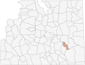
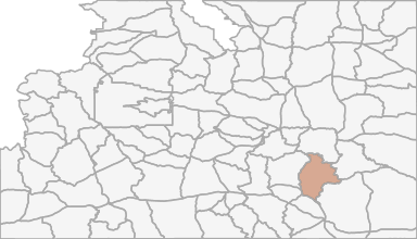
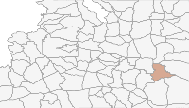
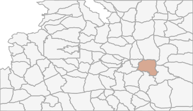
Pronghorn Hunting in Wyoming Hunt Area 41 - Laramie Peak
Beginning where the Big Laramie River crosses the Dodge Ranch Road; northerly along said road to the Garrett Road (Albany County Road 713); northerly and westerly along said road to the Fetterman Road (Albany County Road 61); southerly along said road to
Scores
Access Notes
With A Free Account Get:
- All Access Information
- Satallite and Topo Layers
- Public Landownership Layers
- Roads and Trails Layers
- Burn Layers
- Water Tank Layer (AZ Only)
Beginning where the Big Laramie River crosses the Dodge Ranch Road; northerly along said road to the Garrett Road (Albany County Road 713); northerly and westerly along said road to the Fetterman Road (Albany County Road 61); southerly along said road to the Mule Creek Road (Albany County Road 64); northwesterly along said road to Albany County Road 610; northerly along said road to Sheep Creek; northerly up said creek to the southern boundary of the Laramie Peak Division of the Medicine Bow National Forest; northwesterly along said boundary to the Albany- Converse county line; east along said line to LaPrele Creek; southerly up said creek to the divide between LaPrele Creek and the Little Medicine Bow River; easterly along said divide to the divide between Corduroy Creek and Rocky Ford Creek; easterly along said divide to the Fetterman Road (Albany County Road 61); southerly along said road to U.S.F.S. Road 658; easterly along said road to South Fork Creek, tributary to LaBonte Creek; southerly up said creek to the divide between Horseshoe Creek and the North Laramie River; southeasterly along said divide to the head of Friend Creek; southerly down said creek to Bear Creek; easterly down said creek to the North Laramie River; easterly down said river to the Cottonwood Park Road (Albany County Road 71); southerly down said road to its junction with the Palmer Canyon Road (Albany County Road 721); easterly along said road to Ashley Creek; southerly down said creek to Duck Creek; easterly down said creek to the Big Laramie River; southerly and westerly up said river to the Dodge Ranch Road.
Pronghorn Notes
With A Free Account Get:
- Toggle between terrain, satellite, and topographic views
- Additional species-specific map layers
- Full screen maps
- Complete species hunting information
HuntScore Tip
Only non‐Indian owned, fee title lands are open to the taking of wildlife with a Wyoming license. Land status is complicated and lawful access must be investigated thoroughly. Sportsmen are advised it is their responsibility to determine land status prior to entering these areas.
State Agency Website
Visit Wyoming Game & Fish DepartmentBusinesses Serving Pronghorn Hunters In Hunt Area 41 - Laramie Peak
Advertise Your Business!

Category: Guide/Outfitter
: 555-555-5555
About
Are you an outfitter, hunting guide, game processor or local hotel? Do you have landowner tags, lease land, or have an lodge? Advertise on HuntScore and reach hunters interested in this hunting unit! Send us an email at [email protected] to learn more. Read about advertising on huntscore here
Photos and Terrain Notes
Similar Nearby Pronghorn Units
TrailHead Chatter
With A Free Account Get:
- Ability to read comments
- Ability to post comments
- Ability to upvote and downvote comments