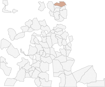
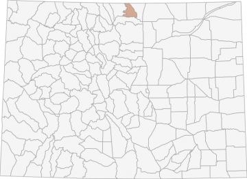
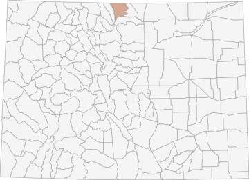
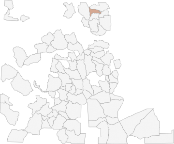
All Hunting in Colorado GMU S40 - Lone Pine

The overall climate in this area is relatively dry with low humidity. Climate varies across the DAU as a function of elevation. Conditions on the eastern edge of S40 are standard for the foothills/short grass prairie interface, with relatively mild winter

GMU S40 - Lone Pine

Scores


Scores
User Scores
Ease of Drawing
3
 
3
Success
0
 
N/A
Trophy Potential
0
 
N/A
Public Access
50
 
50
Ease of Terrain
80
 
80
Room to Breathe
100
 
100
Opportunity
9
 
9
Convenience
100
 
100
Ease of Effort
0
 
N/A
59
HuntScore

Access Notes


With A Free Account Get:

  • All Access Information
  • Satallite and Topo Layers
  • Public Landownership Layers
  • Roads and Trails Layers
  • Burn Layers
  • Water Tank Layer (AZ Only)

Bounded on N by County Roads 80C and 59 (Cherokee Park Road) and WY; on E by County Road 37, South Branch Boxelder Creek, Boxelder Creek, County Road 19; on S by County Road 80, and US Highway 287; and on S and W by County Roads 74E and 162 (Red Feather Lakes-Deadman Road).

County

Larimer

Size

427 Square Miles (273,099 Acres)

Land Ownership

45% Private, 55% Public, 38% USFS, 12% State, 4% Other

Latitude/Longitude

40.8757, -105.4735

Amenities

There are 0 hospitals, 20 hotels, 20 campgrounds, and 6 grocery stores within a 20 mile radius.

All Notes


With A Free Account Get:

  • Toggle between terrain, satellite, and topographic views
  • Additional species-specific map layers
  • Full screen maps
  • Complete species hunting information

HuntScore Tip

Many units in pronghorn country are located on private land. However, many have been rated as good access locations. Landowners are more likely to give you permission to hunt pronghorn than deer.

State Agency Website

Visit Colorado Parks and Wildlife

Businesses Serving All Hunters In GMU S40 - Lone Pine


Advertise Your Business!

Category: Guide/Outfitter

: 555-555-5555

: [email protected]

: www.yourbusiness.com

About

Are you an outfitter, hunting guide, game processor or local hotel? Do you have landowner tags, lease land, or have an lodge? Advertise on HuntScore and reach hunters interested in this hunting unit! Send us an email at [email protected] to learn more. Read about advertising on huntscore here

Photos and Terrain Notes


The overall climate in this area is relatively dry with low humidity. Climate varies across the DAU as a function of elevation. Conditions on the eastern edge of S40 are standard for the foothills/... Create a free account to read the rest of this terrain note!

All Drawing Stats (2022)


Total Quota
3
Licenses Drawn
3
Licenses Surplus
0
Resident Quota
3
Nonresident Quota
0
Landowner Quota
0
Youth Quota
0
2.7%
Overall Unit
1st Choice Draw Odds
Choose a hunt below to take a deeper dive into quotas, drawing odds, drawing trends, and harvest data.
Stats Apply For Sex Manner Season Type Draw Odds HuntScore Notes
SMS40O2R
M
R
O2
LL
1.9%
67 License Valid for Units: S40, S58 ;
SMS40O1R
M
R
O1
LL
2.2%
65 License Valid for Units: S40, S58 ;
SFS40O1R
F
R
O1
LL
7.7%
68 License Valid for Units: S40, S58 ;
HuntScore Tip: You are able to receive a refund for your license as long as the season has not started. You would have to fill out the License Refund Application or Preference Point Restoration form and return the license and carcass tag with the application to Colorado Parks and Wildlife. Preference Points will be restored to the pre-draw level, and you will not receive a preference point for that year.

Go Pro and get:

  • Most up to date data!
  • Drawing trends across multiple years
  • Individual hunt quotas
  • 1st choice license applications and licenses drawn
  • Draw odds for resident and nonresident applicants
  • Minimum preference points to draw
  • Point creep plots

See all stats but the last 2 years with a free account!

All Harvest Stats (2014)


Total Hunters
0
Total Harvest
0
Harvest Male
0
Harvest Female
0
0%
Average Success
Manner Season Type Sex Hunters Harvest Male Female Youth
Any
All
LL
E
0 0
0
0
R
O1
LL
E
0 0
0
0
HuntScore Tip: Hunters who have GPS units are encouraged to mark the location of their harvest in the field. This is especially important for hunters who harvest a bear or moose. During mandatory inspections, hunters will be asked to give a location of their harvest. Having GPS coordinates makes reporting simple and precise.

Go Pro and get:

  • Most up to date data!
  • Harvest trends across multiple years
  • Harvest stats by hunt_code, manner, season, sex, type
  • Average harvest rates
  • Average days per hunter
  • Overall harvest trends

See all stats but the last 2 years with a free account!

TrailHead Chatter


Sign Up or Sign In to Read !

With A Free Account Get:

  • Ability to read comments
  • Ability to post comments
  • Ability to upvote and downvote comments